WILDIFRE PLANNING EFFECTIVENESS OF 58 CALIFORNIA COUNTIES
UP221 Final Presentation Story Map
Chendi Zhang
Introduction & Research Question
Wildfires, exacerbated by climate change, are a growing planning and policy challenge worldwide, particularly in California. In this study, we analyze the impact of local planning efforts on lessening community vulnerability to wildfires. We examine the effectiveness of local mitigation efforts in California's 58 counties, as outlined in the Fire Adapted Community (FAC) framework, and focus on three primary local planning mechanisms: the General Plan (GP), Hazard Mitigation Plan (HMP), and Community Wildfire Protection Plan (CWPP). We first generated content analysis protocols for each planning mechanism based on their respective policy guidelines, and aligned the quantified content analysis with a Wildfire Social Vulnerability Index.
The result of this analysis enabled us to assess wildfire management through these planning mechanisms, and to identify common gaps in wildfire management measures across counties. The results provide insights into the effectiveness and shortcomings of planning tools in addressing wildfire resilience measures in California's counties. We conclude with implications for planning guidelines and policy-making, aiming to strengthen future wildfire management.
Research Questions:
-
If and how the wildfire planning effectiveness (PE) of 58 CA counties spatially distributed differently?
↓
Visualize the wildfire PE of 58 CA counties (spatial pattern)
-
Does social vulnerability index (SVI) impact wildfire planning effectiveness (PE) of 58 CA counties?
↓
Regression analysis of SVI & PE

Data & Method
Wildfire Planning Effectiveness (PE) scores:
Wildfire planning effectiveness scores are a set of quantified content analysis data created by Firetools_UCOP_HUD research team. Wildfire planning effectiveness examines how the wildfire-related planning mechanisms - General Plan (GP), Hazard Mitigation Plan (HMP), and Community Wildfire Protection Plan (CWPP) conform to the wildfire management and resilience development.
Social Vulnerability Index (SVI) scores:
Social vulnerability refers to the potential negative effects on communities caused by external stresses on human health. Such stresses include natural or human-caused disasters, or disease outbreaks. Reducing social vulnerability can decrease both human suffering and economic loss.
The CDC/ATSDR Social Vulnerability Index (CDC/ATSDR SVI) uses 16 U.S. census variables to help local officials identify communities that may need support before, during, or after disasters.
The Spatial Distributions of Wildfire Planning Effectiveness in Total and Plan-specifically
Geographical disparity of PE
-
The counties along the California coast have higher planning effectiveness scores in each of their three plans and in total than the inland counties.
-
The counties at the north-west have higher planning effectiveness scores in each of their three plans and in total than the counties at the south-east.
-
The geographic location and the resources available to these counties may influence their planning and prioritization efforts in wildfire. For example, the wealthier coastal and more urbanized counties like Los Angeles and San Francisco may face different challenges and priorities than more rural counties like Siskiyou or San Bernardino, affecting their plan scores.
Most CA counties have a way higher PE score in HMP than that in GP and CWPP
-
HMP’s planning mechanism nature. HMP is a specified plan for natural hazard mitigation. The plan structure and items are developed specifically for all kinds of natural hazards. Wildfire, as one of the most common natural hazards in California, is less likely to be overlooked or omitted in HMPs.
-
Better guideline development of HMP. The HMP guidelines not only provide a clear framework showing all the required items but also give a checklist to help each state, county, or community self-review the required items.


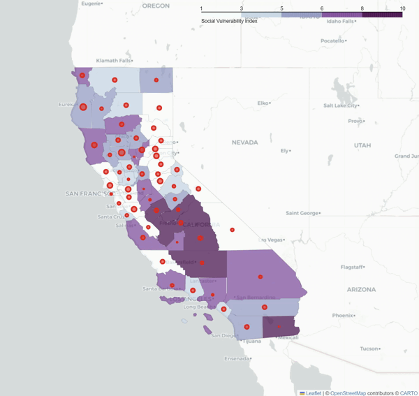
INTERACTIVE MAP -
SPATIAL PATTERNS OF PE-SVI OVERLAY
We reclassified the Social Vulnerablity Index of 58 CA counties into 1 -10, and overlayed the overall Wildfire Planning Effectiveness (PE) scores as dots in different diameters.
The bigger the dot is, the higher PE of that county is. The darker the county is, the more socially vulnerable that county it.
Interact with the map or go to the link below:
https://chendizest.github.io/UP221-CHENDI/week10_final/WILDFIRE_SVI_PE6.html
The Spatial Distributions of Wildfire Planning Effectiveness in Total and Plan-specifically
To futher examine the association between PE and SVI to see if and how SVI impacts PE for 58 counties, we ran regression analysis between PE and SVI. SVI is the indpendent variable, and PE is the dependent variable.
To compare the association between PE and SVI and the associations of PE and other index, we also ran two regression analysis between PE and WFR (Wildfire Risk Index by FEMA, 2022), and between PE and WHP (Wildfire Hazard Potential scores by Dillon, 2023)


SVI has a moderate negative association with PE.
-
R² = 0.104, coefficient = -0.1203, p = 0.014 < 0.05.
-
The higher SVI score (the more socially vulnerable the county is), the county tends to have
a lower PE score.
CONCLUSIONS & POLICY IMPLICATIONS
-
Geographically specific wildfire planning and management for the CA counties with distinct geographic features (coastal vs. inland, urbanized vs. rural).
-
Wildfire-specific planning guidelines and checklists to be improved in GPs and CWPPs
-
More efforts of wildfire planning and management need to be made for the CA counties that are more socially vulnerable.

ACKNOWLEDGEMENT AND REFERENCE
Instructor:
Christopher Giamarino
Research Team:
Co-PIs: Crystal Kolden, Anastasia Loukaitou-Sideris
Project Manager: Nicole Lambrou
Research Lead: Chendi Zhang
Research Assistant: Yu-Chen Chu
Main Reference:
“Community Wildfire Protection Plan Portal and Data Library.” Fire Adapted Communities, 29 Aug. 2022, fireadapted.org/cwpp-database/.
Hwang, Seong Nam, and Kayla Meier. "Associations between Wildfire Risk and Socio-Economic-Demographic Characteristics Using GIS Technology." Journal of Geographic Information System 14.5 (2022): 365-388.
Andersen, Lauren M., and Margaret M. Sugg. "Geographic multi-criteria evaluation and validation: A case study of wildfire vulnerability in Western North Carolina, USA following the 2016 wildfires." International journal of disaster risk reduction 39 (2019): 101123.
“Planning for Climate Change Takes a Comprehensive Approach.” ResilientCA, resilientca.org/plan-alignment/. Accessed 12 July. 2023.
Shahab, Sina, J. Peter Clinch, and Eoin O’Neill. "Impact-based planning evaluation: Advancing normative criteria for policy analysis." Environment and Planning B: Urban Analytics and City Science 46.3 (2019): 534-550.